The Canary Islands are a popular tourist destination in Europe and millions of people travel to the Spanish archipelago of volcanic origin every year. La Gomera is the second smallest island in the Canary Islands and attracts active tourists in particular with its breathtaking nature and idyllic volcanic beaches.
The island, which is a UNESCO biosphere reserve, delights hiking enthusiasts with an impressive variety of landscapes. From rugged coastal paths to fertile valleys and remote mountain villages. Off the beaten track of the tourist hotspots, this island is a true paradise for nature lovers who long for unforgettable hiking tours.
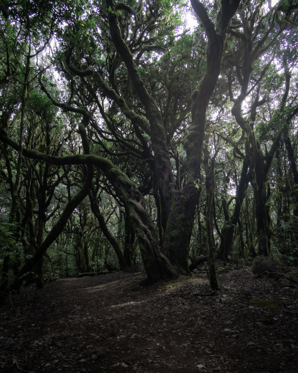
An absolute highlight is the Garajonay National Park, a dense cloud forest that is steeped in mystical charm. Here, the evergreen laurel forests tower majestically and create a backdrop that looks like something straight out of a fairy tale.
In this blog post, I present three hikes in the Garajonay. For me, these hiking tours were an absolute highlight of my hiking vacation on La Gomera. I hope you enjoy reading and am delighted that you have found my travel blog.
The Garajonay National Park on La Gomera is a real gem for hiking enthusiasts, offering a unique blend of nature and culture. As a UNESCO World Heritage Site, this cloud forest offers a breathtaking backdrop characterized by dense laurel forest, moss-covered trees and mystical fog. The numerous hiking trails in Garajonay National Park lead through this fascinating ecosystem and offer an incomparable experience of nature. The paths wind through dense forests, past mossy rocks and hidden springs, and lead to spectacular viewpoints from which you can enjoy unique views of the lush green valleys and the Atlantic Ocean. There is so much to discover when hiking on the numerous hiking trails in the Garajonay. You shouldn’t miss these highlights during your La Gomera vacation.
My hikes on La Gomera
I present three exciting routes that I have hiked myself on my travel blog. The first circular hike runs in the western region of La Gomera from the mountain village of Arure through the Acardece Valley to the mystical Garajonay. This hiking tour promises breathtaking forest scenery, great views and varied terrain.
If you are looking for more hikes on La Gomera, then take a look at this book. I personally really like this series of hiking guides. The book is small and handy, offers useful information about hiking, and detailed descriptions of the hikes. I’ve already discovered some great hikes that I wouldn’t have found without these books.
How to get to Garajonay National Park on La Gomera
Travel by car
The Garajonay fairytale forest is located in the center of La Gomera. As most of the roads on the volcanic island run through the center, you won’t miss the cloud forest. The drive from the capital San Sebastián de la Gomera takes around 30 minutes. The roads are well-maintained and pass beautiful viewpoints that are well worth stopping at. Due to the winding roads, a leisurely driving style is advisable to make the journey relaxing and safe. Free parking is available at various points in the national park, from where you can set off on hiking adventures to the impressive laurel trees and panoramic views.
For accommodation search I recommend the platform Booking.com. Here I book most of my hotels and I have always been satisfied with the offers and prices.
The best starting points for the best hikes in the Parque Nacional de Garajonay are the central towns on the island. El Credo and Las Hayas in particular offer accommodation* The towns are very remote and don’t offer much apart from pure nature. If you need restaurants, stores, beaches and other tourist facilities, it is better to stay in larger towns. I myself stayed overnight in Valle Gran Rey* and was very happy with what was on offer.
Of course, there are countless other towns on La Gomera that offer accommodation. Below you will find a selection for the entire region around the Garajonay.
Hiking Tour 1: Arure – Casas de Acardece – Cañada de Jorge – Raso de la Bruma
Varied hiking experience in the Garajonay laurel forest
My first hike is in the south-western region of Garajonay and starts in the village of Arure. The varied circular hike is around 10.5 kilometers long and leads across lush terraced crops into the cloud forest of La Gomera. The tour also offers breathtaking views of the lush landscape of the Canary Island.
The hiking tour does not require any particular hiking experience, but you should be in good physical condition. The paths are well developed and signposted. Nevertheless, hiking boots are a must on the forest paths, some of which are rooty. There are no refreshment stops on the hike except in Arure. I have marked the hiking route and all important destinations on the hiking map.
The small mountain village is located between Valle Gran Rey and Vallehermoso, which are connected by the GM-1 road. Due to the many hairpin bends, the drive from Valle Gran Rey and Vallehermoso takes around 25 minutes. Free parking is available directly on the road opposite Restaurante Casa Conchita (see map).
Alternative starting points for the hiking route are the free parking lots at the Raso de la Bruma or at Las Creces.
From Arure to the Casas de Arcardece
We park our rental car in the small parking lot and follow the GM-1 50 meters uphill to a crosswalk. There, a path on the right-hand side leads down into the Barranco de Arure. The stony path runs through picturesque green terraced crops on which a wide variety of exotic plants grow. In the district of Casas de Arcardece, the hiking trail leads back to the main road GM-1. After the bend, we follow the Cam. de la Quintana road to the Embalse de Arure reservoir. From there, the trail leads us further into the valley to the La Gomera cloud forest.
Barranco de Arure
Casas de Acardece near Arure
Short Facts for your Trip
When to go
Travel Duration
Accommodation
Transport
Equipment
Camera
When to go
La Gomera is an ideal destination for hiking enthusiasts all year round. In spring, the island blossoms with mild temperatures and colorful nature. Summer offers warm conditions, especially in the mornings and evenings. Autumn offers pleasant temperatures and a quieter atmosphere. The mild winter allows for coastal hikes and tours along fascinating rock formations. Regardless of the season, hikers should always be prepared for the local weather conditions and take appropriate equipment with them.
Travel Duration
I spent 7 days on La Gomera and visited a few other sights in addition to the hikes in Garajonay. However, it is worth staying longer. Other highlights await you such as the beautiful Playa de Valle Gran Rey, the Land of the Red Earth, picturesque mountain villages like Agulo and countless viewpoints. Above all, La Gomera offers great other hiking opportunities, which are described, for example, in this great hiking guide*
Accommodation
The best starting points for the best hikes in the Parque Nacional de Garajonay are the central towns on the island. El Credo and Las Hayas in particular offer accommodation* The towns are very remote and don’t offer much apart from pure nature. If you need restaurants, stores, beaches and other tourist facilities, it is better to stay in larger towns. I myself stayed overnight in Valle Gran Rey* and was very happy with what was on offer.
Transport
The easiest way to get around La Gomera is with your own car.
Traveling by bus is also possible, but you will need to plan for a lot more time. Bus transport on the Canary Islands is generally very well organized and also cheap. The main bus route in Garajonay National Park is line 1. You can find more information on the island’s transport company website.
Equipment
Some of the hikes lead over rooted forest paths and rocky nature trails, which is why hiking boots are mandatory. The Garajonay laurel forest is known for changeable weather, so you should also bring rainproof clothing with you. Don’t forget sunscreen and a hat.
Camera
There are endless ways to use your camera while hiking. Especially landscape photography of the vastness of the coast or the mountains of La Gomera. It’s best to think of a telephoto or wide-angle lens. A light travel tripod is ideal for taking photos in the dark cloud forest.
Laurel forest near Cañada de Jorge
We soon reach a national park sign and hike along a forest path into the Garajonay cloud forest. The Cañada de Jorge hiking trail leads us uphill into the laurel forest, which overwhelms us just a few seconds after entering. An endless sea of plants, rising up in the most varied shades of green, accompanies us on our captivating hiking experience to the Raso de la Bruma rest area. The fairytale forest of La Gomera has already exceeded our expectations.
Laurel forest near Cañada de Jorge
Laurel forest near Cañada de Jorge
Viewpoints in the Garajonay fairytale forest
After bravely crossing the GM-2 road, we continue our expedition through the mysterious laurel forest. This section reveals itself as an enchanted circular trail that leads us past numerous viewing platforms, including the fascinating Mirador Risquillos de Corgo. From the impenetrable thicket of the Garajonay forest, these viewpoints suddenly give us breathtaking panoramas: The vast ocean spreads out majestically before us, while the green peaks of La Gomera stretch up into the sky in rugged majesty.
Back at the Raso de la Bruma, we continue on our way, turn right and follow the GM-2 until the mysterious Cañada de Jorge finally takes us back into the dense forests. Here, in the heart of the Garajonay, a fascinating landscape unfolds, characterized by majestic laurel trees, dreamy tree heather and the aromatic wax gall. The variety of plants creates an enchanting atmosphere that turns every step into an adventure in a living fairytale land. Step by step, La Gomera reveals its secrets, and with every hike it becomes clear why this island is an absolute highlight for travelers.
Laurel forest near Raso de la Bruma
Laurel forest near Raso de la Bruma
Return route through the Barranco de Arure
We leave the Garajonay with a touch of melancholy, determined to explore this magical realm again. On the way back to the small reservoir in Arcardece, we enjoy the familiar hiking trails. From there we continue our hike, following a mountain path along the lush Barranco de Arure with breathtaking views. Passing a tiny reservoir, the descent leads us over rocks and along a canal back to the main road GM-1. Every step reveals not only the beauty of this landscape, but also the anticipation of future adventures on the fascinating island of La Gomera.
Hiking Tour 2: Alto de Garajonay – Barranco del Credo – Reserva Natural Integral de Benchijigua
Grand tour in the heart of the Garajonay
My second hike is located in the heart of the Garajonay and starts on the GM-1 high road. The picturesque hiking tour is around 13 kilometers long and runs over the highest peak in La Gomera and then leads into the depths of the mystical laurel forest. Afterwards, spectacular views of the bizarre rock formations of Los Roques await you.
The hike is long and you should be in good physical condition. You mainly hike on forest paths here, which become slippery when it rains and have many tripping hazards. Sensible hiking boots and sure-footedness are a must. There are no refreshment stops on the hike, but drinking water is available halfway through. I have marked the hiking route and all important destinations on the hiking map.
My hiking experience starts at the foot of the Alto de Garajonay in the center of La Gomera. There is a large traffic circle with the free parking lot Aparcamiento de Cruce de Pajarito, which can be reached via the GM-2 road. The drive from Valle Gran Rey, Vallehermoso or San Sebastian takes around 45 minutes.
The Pajaritos bus stop is also located at the traffic circle and is served by bus line 1. Further information can be found on the website of the La Gomera transport company.
Alternative entry points are the parking lots at El Contadero or at the Mirador de Tajaqué, as well as the Cruce de la Zarcita bus stop (see map).
Hike to the highest point of La Gomera
From Pajarito, we set off to experience nature, following the signs to the summit. The path winds steeply upwards, sometimes over steps, while the first rays of sunlight bathe La Gomera in golden light. We soon reach the Alto de Garajonay, the highest point on the island. A circular panoramic platform gives us an overwhelming 360-degree view – majestic cliffs, shimmering sea, dreamy mountain villages and dense forests. A gripping start to an unforgettable hike in the Canary Islands.
Viewpoint Alto de Garajonay
The highest point of La Gomera
Hike through the laurel forest of La Gomera
Along a paved path, we descend on the other side towards the Alto del Contadero parking lot, which provides direct access to the fairytale forest. The hiking trail leads us steadily downhill through shady heather and picturesque laurel groves, often accompanied by steps. After about 30 minutes, we reach a viewpoint where we can stop for a moment. We then continue our descent through the fascinating Garajonay forest, an adventure that allows us to immerse ourselves deeply in the nature of La Gomera.
Garajonay laurel forest
Garajonay near Bosque del Credo
We reach the picturesque Credo stream, which will be our constant companion on our hiking tour from now on. Several times we pass small waterfalls and cascades that fight their way through the impenetrable undergrowth of the Garajonay. Our hiking trail crosses the Barranco del Credo several times and leads us along the stream, always in the direction of the village of El Credo.
Laurel forest near Barranco del Credo
Laurel forest near Barranco del Credo
In the heart of the Garajonay National Park
Our hike takes us through the diverse zones of the Garajonay. In the heart of the national park, we reach the enchanting chapel Ermita de Nuestra Senora de Lourdes, a popular destination for the Gomeros. Here, at a rest area, we have the opportunity to replenish our energy reserves and water bottles. After a short section in the forest, a cobbled road surrounded by laurel groves leads us uphill to the CV-14 road, where the magical Reventon Oscuro finally awaits us.
Laurel forest near El Credo
Laurel forest near El Credo
If you’re looking for a travel guide to the Canary Islands, then take a look at this book. I personally really like this series of travel guides. The authors give travel tips especially for individual and low-budget travelers. In addition, not only the well-known sights are described, but lesser-known places are also mentioned.
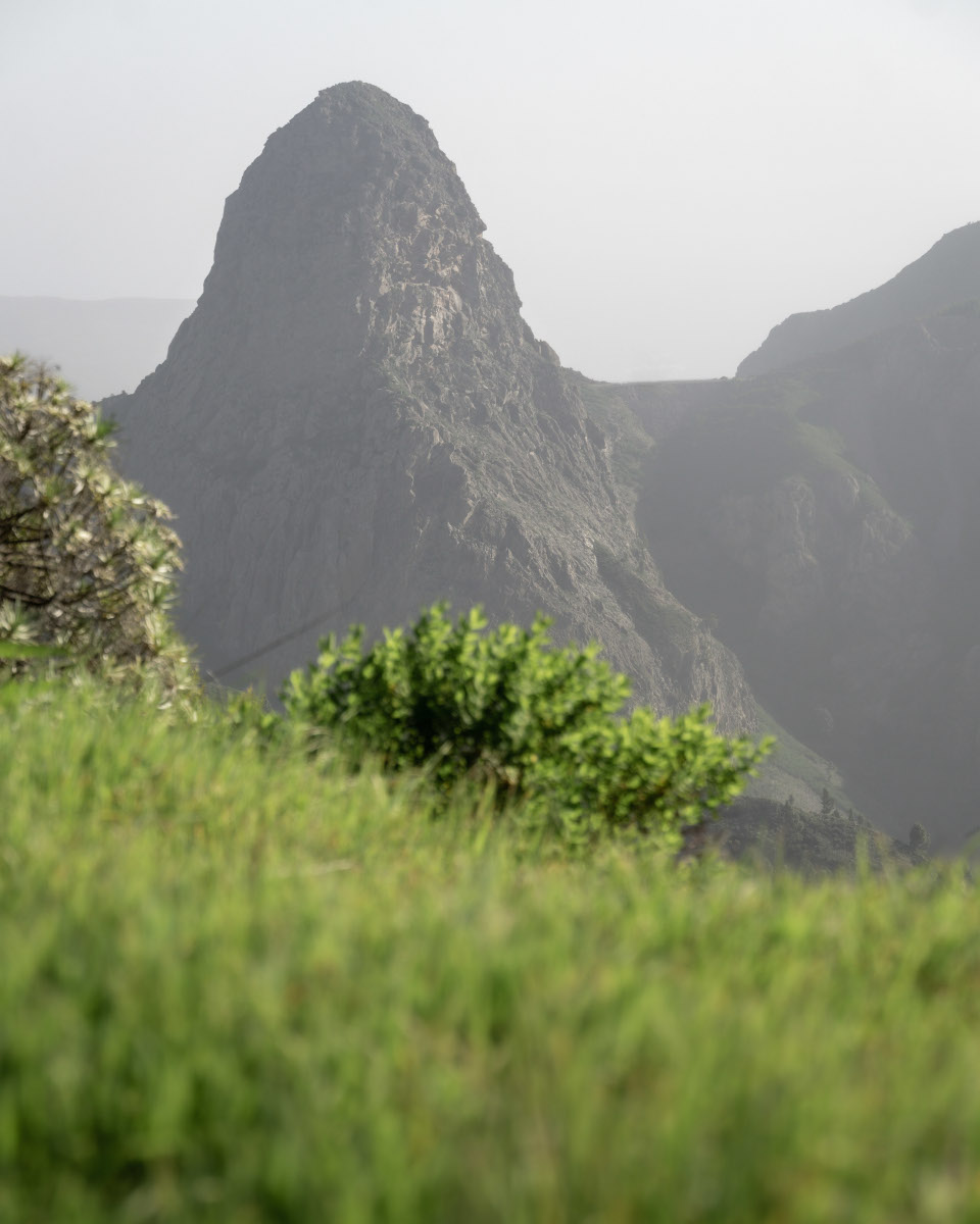
At the CV-14, we follow the signs to La Zarcita and enter the forest near Reventon Oscuro. Our path runs parallel to the road, but through the dense, fairytale-like cloud forest, civilization seems a long way off. On narrow paths, we cross challenging, mountainous terrain in the heart of the Garajonay forest. Finally, we reach a spectacular viewpoint that affords us a breathtaking view of the mighty rocks of Los Roques, undoubtedly the most impressive natural wonders of La Gomera.
Viewpoint of Roque de Ojila and Roque de la Zarcita
Roque de Agando – the landmark of La Gomera
We cross the main GM-2 road and hike back into the forest on a narrow path. The last section of our route runs along the GM-2 to Pajarito, lined with several indescribable viewing platforms that give us breathtaking views of the majestic Roque de Agando. The view leaves such a deep impression that we decide to return the next day at sunrise. You can see the fascinating pictures of the morning here.
View of Mirador del Morro de Agando with Pico de Teide in the background
Roque de Agando at sunrise
If you prefer to travel in a group, you have the option of joining a guided tour. You don’t have to worry about getting there, planning excursions or catering, but can concentrate completely on the beauty of the Garajonay. I recommend booking a tour via the Viator portal, where countless activities around the world can be booked easily and securely.
Hiking Tour 3: Pajarito – Lajugal – Calderas de Imada
Panoramic high trail in the south of the Garajonay
My third hike takes me through the southern foothills of the Garajonay. This is a high-altitude trail covered in conifers with magnificent views of the Calderas de Imada, the Benchijigua valley or the Roque de Agando.
The route is 7.5 kilometers long and does not require much effort. The well-maintained hiking trails lead through pine forests and pass magnificent viewpoints of the south of La Gomera. There are no refreshment stops on the hike and very little shade. Provisions and sun protection are advisable. I have marked the hiking route and all the important destinations on the hiking map.
My hiking experience starts at the foot of the Alto de Garajonay in the center of La Gomera. There is a large traffic circle with the free parking lot Aparcamiento de Cruce de Pajarito, which can be reached via the GM-2 road. The drive from Valle Gran Rey, Vallehermoso or San Sebastian takes around 45 minutes.
The Pajaritos bus stop is also located at the traffic circle and is served by bus line 1. Further information can be found on the website of the La Gomera transport company.
From Pajarito towards Imada: through pine forests and quiet valleys
From Pajarito, we hike along a picturesque forest path that leads us directly into the forest. A wooden signpost points us in the direction of “Imada”. At the later fork, we decide to follow the path to the right, down into the green paradise. We then turn left at the next pine grove and continue on our path. The forest road leads us unchanged through the shallow valley incision. A different facet of the landscape opens up here, characterized by majestic pine trees instead of the familiar laurel groves of the Garajonay.
If you are looking for more hikes on the Canary Islands, then take a look at this book. The book is small and handy, offers useful information on hiking and detailed descriptions of the hikes.
We hike through dreamy pine forests, which are slowly replaced by fascinating Fayalbrezal formations. The evergreen mountains of the south coast of La Gomera rise majestically in the distance. The views of the Calderas de Imada are simply breathtaking. The village of Imada spreads out before us, nestled in a valley surrounded by the striking rocks of volcanic beauty.
Views of the Benchijigua Valley
The views of the southern slopes soon disappear, but new perspectives open up with views of the impressive calderas of Benchijigua to the east. The monumental rocks of Los Roques loom in the distance, led by the striking Roque de Agando, a symbol of La Gomera. Our route takes a westerly turn, leads us through similar vegetation and finally brings us back to the junction. After an uplifting climb, we return to Pajarito. Every step reveals not only the changing landscape of the Garajonay, but also the impressive diversity of this unforgettable journey.
Roque de Agando in the distance
Conclusion on hiking in the Garajonay on La Gomera
Hiking in the Garajonay National Park on La Gomera is an unforgettable experience for every nature lover and hiking enthusiast. The spectacular views of green valleys and surrounding islands, the lush vegetation and the mystical cloud forest offer a diverse selection of outdoor activities. The area is ideal for hikers looking for new challenges, but also for beginners and families with children who simply want to enjoy nature. The trails are well marked, but also demanding and require a certain level of physical fitness. Overall, hiking in the Garajonay is an unmissable experience for any visitor to La Gomera who wants to experience the beauty of nature and the challenge of hiking. For me, the Garajonay cloud forest was an absolute highlight of my trip to the Canary Islands.
I hope you enjoyed my travel report about the hiking opportunities in the Teno-Mountains. On my travel blog, I show you other beautiful destinations on the Canary Islands and share valuable tips and experiences for your trip to Spain. Did you like my blog post? Was I able to help you? Then I would be delighted if you would recommend my travel blog, leave a comment or follow me on Instagram. Thanks for reading and have fun on your Canary Islands vacation.
The references marked with an asterisk (*) are so-called commission links. If you click on such a referral link and buy something, I get a small commission from the provider. For you, the price does not change! I see it as a small thank you for my work and look forward to any support.
The display of the products was implemented with the affiliate-toolkit plugin.
We use cookies to optimize our website and service.
Functional
Always active
Technical storage or access is strictly necessary for the lawful purpose of enabling the use of a particular service expressly requested by the subscriber or user, or for the sole purpose of carrying out the transmission of a message over an electronic communications network.
Preferences
The technical storage or access is necessary for the legitimate purpose of storing preferences that have not been requested by the subscriber or user.
Statistics
The technical storage or access, which is carried out exclusively for statistical purposes.Technical storage or access used solely for anonymous statistical purposes. Without a subpoena, the voluntary consent of your Internet service provider, or additional records from third parties, information stored or accessed for this purpose alone generally cannot be used to identify you.
Marketing
Technical storage or access is necessary to create user profiles, to send advertisements, or to track the user on a website or across multiple websites for similar marketing purposes.